Archive Record
Images
Metadata
Title |
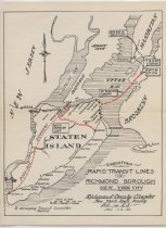
Suggested Rapid Transit Lines in Richmond Borough |
Collection Name |
Transportation Collection |
Date |
1930 |
Description |
Map of Staten Island and the surrounding region printed mostly in black on off-white paper, with proposed transit lines marked in red. Existing rail lines of the B & O (Baltimore and Ohio) Railroad and the Staten Island Rapid Transit Railway are shown, with stations indicated. Proposed lines are a possible extension along the west shore of Staten Island, an inter-borough loop across the north-central portion, and a tri-borough subway from St. George to Smith & 9th Streets in Brooklyn. The map title reads, "SUGGESTED / RAPID TRANSIT LINES / IN / RICHMOND BOROUGH / NEW YORK CITY / Richmond County Chapter / New York State Society / P.E. AND L.S. / APRIL 10TH, 1930 / To accompany Transit Committee Report." (This is a description of a single item within the Transportation Collection, MS233.000.) |
Biography and History |
This document appears to have been prepared by Staten Island's Richmond County Chapter of the NY State Society of Professional Engineers and Land Surveyors. The proposed rail lines (designated in red) were never built, but each of the routes later became the approximate site of a highway (although the connection to Brooklyn - the Verrazano Narrows Bridge - is further south than the proposed subway tunnel entrance). The Staten Island Railway marked its 150th anniversary of operation in 2010. Begun as a private company, the Staten Island firm established an alliance with the Baltimore and Ohio Railroad in 1885. In 1971, the City of New York acquired the Tottenville line, which remains in service as of 2012, operated by the Metropolitan Transportation Authority (MTA). |
Legal Status |
Items represented here are from the collections of the Staten Island Historical Society. Materials reproduced for personal non-commercial use must credit the Staten Island Historical Society. Commercial licensing is available. |
Physical Extent |
Item measures 11.5 inches high x 8.5 inches wide. |
Catalog Number |
MS233.000.ITEM.0003 |
Object Name |
Map |
Archival Description Level |
Item |
Parent Record |
MS233.000 |
Subjects |
Maps Railroad companies Railroads Subways Transportation |
Earliest Date |
1930 |
Latest Date |
1930 |
Lexicon Sub-category |
Documentary Artifact |
Support Acknowledgment |
Online Collections Database record made possible by the Staten Island Historical Society, 2012. |